|
Samoeng Reverse Track Trip Dec 6th
Printed from: GT-Rider Board
Topic URL: http://board.gt-rider.com/topic.asp?TOPIC_ID=1838
Topic:

Topic author: Rusty
Subject: Samoeng Reverse Track Trip Dec 6th
Posted on: 07 Dec 2006 12:15:21
Message:
Well here we are for a dirt trip on December 6th (yesterday) that was a reverse track from a trip done by SilverhawkUSA and others back in the rainy season starting in Samoeng. My apologies in advance if I don’t know all the names of the roads and places, I’m hoping the other guys will add in where I get “lost”!! HeHeHe!! (I just have a map with no GPS or lat/long data)
We all met at the “X Centere” about 1km up on the 1096 from the Mae Rim intersection. The GT-Rider members were (me Rusty) pikey, SilverhawkUSA, BobS, BarryBBQ and Gregg (sorry, don’t know Gregg’s board name if he has one.)
The total dirt portion I believe was tracked out at about 30-35kms.
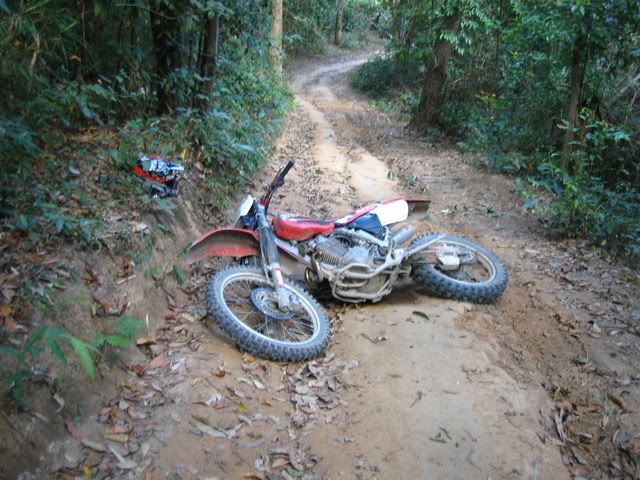
So Gregg had one of these new Chinese 125cc enduros you see for rent around town. The clutch was slipping on him so he opted out at the X centere. Probably a good idea since the trail later would have smoked the clutch out. Bad feng shoi for the Chinese bike I guess.

So off we go to Samoeng, it’s been a long time since my ass had been on an enduro or a bike with knobby tires. OK, so I about shit myself on some of the corners when I could feel the knobbies slipping around, but it’s just been a while for me that’s all!
As we headed off the road and into the trails there was a little confusion since the track was in reverse and the trail was hard packed and dry. After a little off-shooting and backtrack we were back on track (going forward in reverse of course!)

The track was basically through the mountain trails from Samoeng heading south to the elephant camp at Mae Wang. If you have the B&B Thailand North map (best map ever!), it’s more or less a line down from Samoeng to Mae Wang.

There is a mountain about half way, on my map it looks like Doi Mon Pha Sing. The trail in this area was hard packed and rutty. Power to go up and firm control coming down!
It’s my understanding that during rainy season the trail was like riding on baby oil. Some parts of the trail had a very loose silky soil (about 2” or so) with the consistency of baby powder. It makes for some slippery traction if not ready!

There is an old wooden temple (Wat) along the way. Sorry, I don’t remember the name or exact location.

The light was great for the time of day!

All in all it was a great trip for me, being the “cherry” and least skilled of the bunch for the dirt here. It was my first off-road experience in years regardless.
My lessons learned/.02/advice – have a preset “return and rescue” time for fellow riders, obviously carry some tools, parachute cord, etc., and don’t try it alone unless you are ready to pay the consequences!
Oh, and a few trucks did come up the trail, which left little or no room to maneuver if you were hauling balls down the trail to meet one at the corner! Just keep that in the back of your mind!
Thanks again for the invite! Hey I got the bike back before rental closing too! I look forward to more and maybe some whiskey later on to ease the sore asses and bruises! Sookdee!
Replies:
Reply author: barflyrex
Replied on: 07 Dec 2006 16:53:30
Message: Great report and photos Rusty, looks like a great ride.
How many km's was the ride in total, and how long did it take.
cheers Barflyrex
Reply author: BarryBBQ
Replied on: 08 Dec 2006 07:16:30
Message: Map of the ride:

My GPS track from the X-Center to the 1031 @ Mae Win is 94 km with an elapsed time of 5:50. On the Google earth map you’ll see a point labeled “turn here”. We were following Dave’s track from the September ride in reverse and the heavy cover made it hard for his GPS to 1: lay down a good track originally and 2: get good enough reception to follow the original track. That’s the reason for the 15 km detour. I’m not complaining at all, the detour gave us the chance to do 2 water crossings and some interesting single track trails.

Jeff blasting across a bridge.

Silverhawk checking his GPS.

Can’t remember exactly where this waterfall was, somewhere along our detour.

Vertical profile.
Good:
Looking at the vertical profile, you’ll see there is a steep incline for about 5 km – from about km70 to km75. Having just bought a DRZ400, I took this opportunity to test the DR’s power on steep uphills. I’ve ridden similar dirt on my XR250 and I can say that it’s a completely different experience on the DR. On the DR, you can make your own track, pick your own line. On the XR you spend a lot of time changing gears and picking the path of least resistance.
Bad:
When I got to the peak, I talked with this guy,

and confirmed that the mysterious wooden temple that had eluded the group last time out was only 5 km ahead. Rusty showed up and we chewed the fat for a while – comparing experiences about riding styles, different bikes, Alaska vs Thailand, etc. Below, in the valley, we could hear Jeff’s XR400 occasionally. It seemed like we were waiting a long time for Bob, Dave and Jeff but we were convinced that Bob was taking his sweet time on the recently hand graded uphill track. If you’ve ever ridden with BobS, you know what I mean. It turns out that Jeff crashed hard on his XR, Bob was struggling with a clutch that was objecting to the load being putting on it and Dave was the savior that came to both their rescue. Sorry guys, I thought that I flew up the hill so fast on the DR that it just seemed normal for you to take a more time to catch up with me.

Wat Luang.
After the gang caught up with Rusty and me, Dave handed me the national park brochure in a disgusted manner and said, “Your mission, if you choose to accept it, is to find this temple!” At km81, Dave was in the lead and we came to a 3 way intersection. Dave went ahead to confirm that we were going in the direction of his original track and I stopped and read the signs over my shoulder. Dave motioned for us to follow him and I motioned for him to come back. I am unusual for farang in TH because I can actually read Thai better than I can speak it. The Thai sign said Wat Luang, 1km to the left. Dave must have thought I was crazy. I waved at him to come back; he waved at us to follow him. I tooted my horn and he finally gave in and came back. Sure enough, 1 km down the trail was the mysterious wooden temple that was touted in the Ob Khan national park brochure.
 
Dirty Bob, we always knew Bob was dirty – here’s proof.
The votes are in and all agree that BobS’s new nickname should be Bull Dust Bob. There must have been something about the bull dust that Bob liked; he just seemed to want to lay down in it every chance he got. Funny how he favored his right side over his left.
This was a good ride, good riders, no broken bones, and no fisticuffs. I had a 50km ride from Mae Win back home for a well deserved shower. I stopped at the 7-11 and bought a few beers to take home with me and the girls wondered why I had all this brown dirt on my face. I simply told them “pom chop kee mocy tee din”.
Rusty, Thanks for the report, it’s always good to read someone else’s views of a ride. I don’t agree with your claim of being the least experienced rider on this trip – I think BobS earned that title.
Lastly, I want to make a shout out to BigandTall, sorry you couldn’t be here for this ride, we look forward to your return.
Reply author: pikey
Replied on: 08 Dec 2006 10:40:20
Message: Great reports Rusty & Barry!
Just a recap of riders/bikes:
BarryBBQ - DRz400
BobS - DR250
Silverhawk - DR250 Djebel
Rusty - XR250
Me - XR400
and for breakfast at least  , the illustrious(!) moto journalist Dr G (Globerider Greg) on a 125 Platinum rental with a shagged clutch. , the illustrious(!) moto journalist Dr G (Globerider Greg) on a 125 Platinum rental with a shagged clutch.
Myself, SilverHawk and Big&Tall (hope you are green with envy Justin but doing OK cuz we miss you!) did this trip from the Mae Wing end back in September (see http://board.gt-rider.com/topic.asp?TOPIC_ID=1576) and wow, what a difference this time around. Back then it was a mix of buffalo-snot mud and teflon slick hardpack. This time it was completely dry (with the exception of a couple of small water crossings) with a layer of loose rock & bulldust in the turns to catch out the unwary.
Rusty & Barry have done a fine job of describing the route so I'd just like to add my thanks to Silverhawk for playing "policeman" and backtracking to check on his fellow riders when things went a bit wrong and an admirable mention to BobS who with limited dirt experience managed it through, even after his clutch screwed up and meant that it only gripped after the last couple of mm of lever travel 
Agree with Barry about the difference between a 250 and a 400. Last time I did in on my Yammie 250 Raid and a lot of clutch slipping was required to pick out the "right line" on the uphills and ride it trials style. With the XR400 it was simply a case of "point & shoot" and the beast just fired up the steep sections bouncing over obstacles without effort - apart from one incident on a steep, rutted uphill where the bike was definitely more able than the rider:
This resulted in me lying under the bike, winded with my leg trapped until I recovered sufficiently to lever the bike off myself and get both it and me upright again. Smashed the mirror and the speedo(?) and the speedo showed 20kmh at time of impact which is probably why it hurt so much! True to form, Silverhawk appeared a few minutes later to check I was OK and we proceeded onwards and upwards (albeit a bit more gingerly for a km or so on my part!). The other thing about a larger capacity bike is that you have more engine braking so if you are a gutless pussy like me, slippery downhills can be taken clutch out and chug-chug-chug until the nasty bit is over. 
Summary: great ride and definitely easier conditions in the dry. The temple is worth a stop off as you can see from previous pics. There is also fresh water available there, although you'd be crazy not to carry your own with the temperatures and physical exertion faced on a ride like this. I would second Rusty's comment that it would be a good idea that prior to starting out, a timeframe is established between riders so that if one goes missing, wait for say, 5 mins then backtrack and go looking, as although we all rave about "great time, sliding round corners e.t.c", you mustn't lose sight of the fact that we are often in very remote areas with little or no passing traffic and a simple incident could turn into a horror story if you bin it whilst alone.
My personal preference would be to start at the Mae Wing end. Maybe someone is up for doing it again?
Cheers to all,
Pikey.
Reply author: SilverhawkUSA
Replied on: 08 Dec 2006 11:20:32
Message: quote:
After the gang caught up with Rusty and me, Dave handed me the national park brochure in a disgusted manner and said, “Your mission, if you choose to accept it, is to find this temple!” At km81, Dave was in the lead and we came to a 3 way intersection. Dave went ahead to confirm that we were going in the direction of his original track and I stopped and read the signs over my shoulder. Dave motioned for us to follow him and I motioned for him to come back. I am unusual for farang in TH because I can actually read Thai better than I can speak it. The Thai sign said Wat Luang, 1km to the left. Dave must have thought I was crazy. I waved at him to come back; he waved at us to follow him. I tooted my horn and he finally gave in and came back. Sure enough, 1 km down the trail was the mysterious wooden temple that was touted in the Ob Khan national park brochure.
Have to add my 2 satangs:
Many people on the board ask about using a GPS here to explore the trails and mountains. The problem is that anything off the main roads is not shown on the available GPS maps. They are good for finding your way out of somewhere that you have been or to return to a previous track, but that's about all. In the mountains they sometimes lose their accuracy in the heavy tree cover or are blocked by the terrain, as Barry described. Mine went absolutely bonkers at a critical turn and put us on the wrong road. Of course this road was not on the GPS and is not shown on any maps. We agreed to continue to see where it went and thus the 15kms off the track. When we found the road steadily veering to the north and we wanted to go south it was agreed we should go back and take the original route. which we found easily coming in from a different direction (although I think the guys had lost faith at this point).
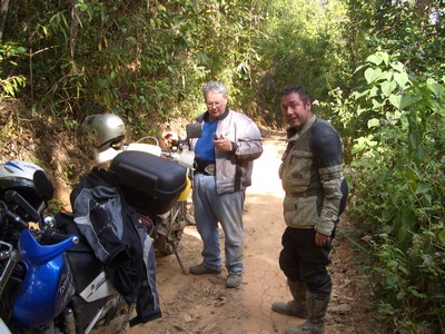
Some tired riders........
Barry your Google overview is great! It really shows the terrain and puts things in perspective. We need to go back and follow some of those trails we passed.
My quest was basically to find the temple that was listed in the National Parks brochure. The problem is that the brochure and the directions from locals we received placed it at the Samoeng end. Wrong! It is only about 8 km from the Mae Win end. When I handed off to BarryBBQ I WAS a little disgusted with the amount of time we had taken to get where we were and the conflicting directions I was getting from locals. I was hoping Barry's skill in reading Thai would pay off and it sure did. The sign that points to the temple is actually quite large and hard to miss, as BobS of course pointed out to me. The full name is Wat Luang Khun Win and is worth seeing
When riding with a group on terrain like this, you can only go as fast as your slowest rider. As stated above, there are no maps or directions to follow so you must stop at every turn or fork in the road to make sure you don’t lose anyone. When trip planning be sure to account for this, along with break downs, getting lost and falling off. After saying that, I should add that I believe David’s new Mae Hong Son Loop map will have this road on it, but there are still many others “uncharted”.
Yes Jeff, I am ready to go back. I would like to go in from Mae Win and get precise directions to pass on so some others can check out this great temple and have fewer problems finding it than I did.
Good reports guys!
PS: Second what BarryBBQ said, missed Big & Tall on this one, your sense of humor and perspective always kept things upbeat.
Reply author: Big & Tall
Replied on: 12 Dec 2006 02:11:44
Message: I'm jealous as hell. You guys sure know how to rub it in, I'm only gone one day and you're off for another dirt bike day. Good stuff.
First off congrats on finding the elusive "wooden temple". We missed it on our first go round with Silverhawk and Pikey but judging from the pics it was worth the wait. Second, great to see some new riders adding to the fold. It was great to meet Rusty, Greg, and BobS socially and hopefully next time spend some time together twisting throttles and collecting bulldust. Though judging by the photos of BobS I'm wondering if he has left any dust on the trails . .
The trails certainly look different from when we did it last. Though i see Pikey in great form throwing his bike down the road. Between Jeff and myself you can always count on a bike being tossed on the ground for the benefit of all the others. After the dirt MHS loop we did and this ride it looks like Jeffs XR 400 has now been properly GT rider tested and deflowered. Glad to see you're OK Jeff.
BarryBBQ hats off to you on posting the Google earth GPS map. It really puts things into perspective. By the way I've got a couple photos I'll email of you impersonating a svelte Thai gal on the back of my NSR. We do look a couple of muppets. Are you planning on searching that single track trail we found down to the Mae Sa valley with the tree across?
So for the gents that have done it both ways (the trail I mean you GT Rider perv's)which way is a more enjoyable direction for riding? There seems to be a lot of land left between Samoeng and Mae Wang to explore for the off-roaders. Also nice to see you guys stumbled across some single track.
Can we lobby BobS for a dirt newbies version of the trail report? Hats off to BobS for stepping up to the plate to go for a ride with you scoundrels with little to no dirt experience.
I must say back here in the states and already missing the good times, laughs, and great rides with you guys.
Reply author: BarryBBQ
Replied on: 12 Dec 2006 05:53:57
Message: quote:
So for the gents that have done it both ways...
I don't know, but I think that was only Pikey and SH. I'm not sure I want to know any more.
Yes, I’m waiting for the photo of me on the back of your NSR.
Bull Dust Bob says that his nickname will never stick but we disagree. All it takes is one ride with him and you’ll understand how he earned that name. Yes, he calls himself BobS or Rider but Bull Dust Bob is his name now. I think the only way he’ll shake that name is if he does another dirt ride with us and beats your record of being upside down underneath the bike three times in an afternoon. As long as there’s bull dust, there will be a Bull Dust Bob. The only bad thing about his new nickname is that if you’ve had a few beers and call out his name, it might come out as bull dog Bob or bull5hit Bob. BTW, BDB has been drafted as the first Mekong River Jump rider as seen here. 
Yeah, I’ve yet to follow that single track. Four of us are on a mission today to take the back trail from the 1096 to Doi Suthep – going uphill instead of downhill like you and I did. Should be good fun.
GT-Rider Board : http://board.gt-rider.com/
© www.gt-rider.com &
www.daearly.com
|